
To jump to a question, just click on it below…
- What do you mean by “Virtual Environments”?
- Will your driving simulator terrains work with my simulator? Are they “plug & play”?
- Can you scan real-world locations to create accurate environment models?
- Do you sell off-the-shelf driving simulators?
- How do your RapidRail tools help de-risk ERTMS rollout?
- Can you supply simulation visuals of real-world railway locations?
- What railway simulators does RapidRail work with?
- What do you mean by “Realtime Simulation Visuals”?
- What is virtual 3D content?
- What are Virtual Reality (VR), Augment Reality (AR), Mixed Reality (MR) and “XR”
- Can you give me a demonstration of your software?
- What are interactive 4D technologies?
- How much does it cost to develop an interactive 3D application and how long does it take?
- How much does it cost to develop a new driving simulator environment and how long does it take?
- What is a Train Driver DMI?
- What is a typical project size? Is any job too big or too small?
- What will be needed from me during the project lifecycle?
- Can Agility3 solutions integrate with my existing systems?
- What type of data would be needed for my project?
- I’m not able to provide the required data – is that a problem?
- I think my business could benefit from an interactive 3D or 4D application, but, I would like to try and test a solution before fully investing – is that possible?
- Can I have an interactive 3D application launched and accessed through the internet?
- Who will own the Intellectual Property of the solution developed for my project?
- Do you provide maintenance and support on the solutions you develop and deliver?
- Why should I choose to work with Agility3?
- I want to work with you, what should I do next?
1. What do you mean by “Virtual Environments”?
A virtual environment is a digital space that replicates a real-world space or environment, perhaps based on scans of that location. It could also represent a fictional environment, or something that is planned but not yet built. It is created using computer software.
A virtual environment typically includes 3D models and algorithms that replicate various physical and behavioural properties of the real world. This can include 3D graphical representations as well as physics and interactive components, for example traffic lights that can be switched or maps that describe driving routes, rights of way or object types.
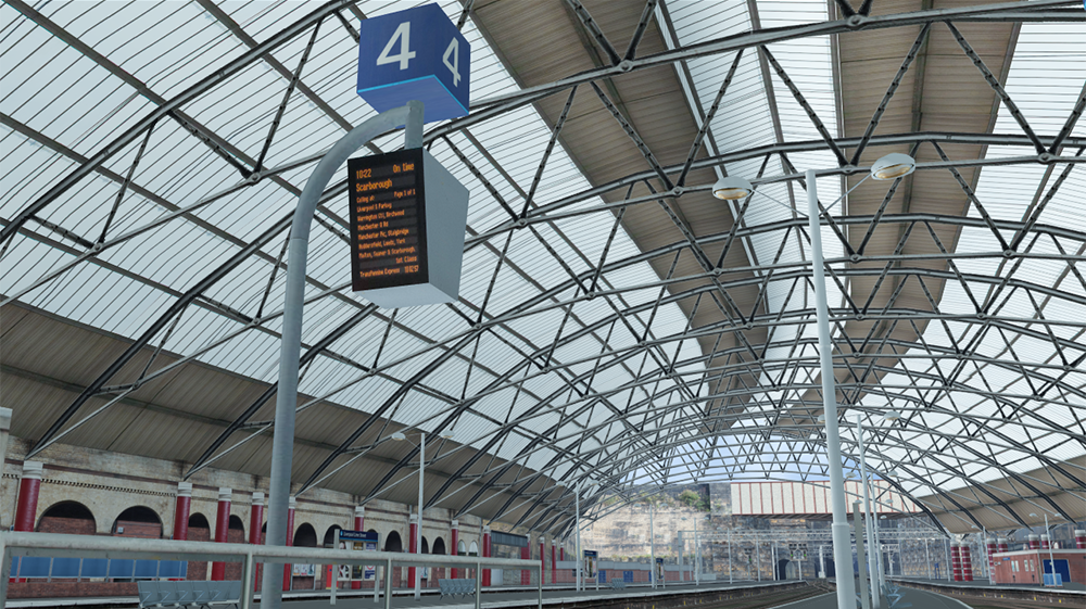
Virtual environments are used for various purposes, such as training simulations, scientific research, system development, validation and testing. They allow users and software test platforms to interact with a simulated world, manipulate objects, and observe how systems or people respond in different situation. Virtual environments can be designed for a variety of applications, and we specialise in those for the rail and automotive industries, as well as providing virtual environments for the aerospace, defence and construction sectors.
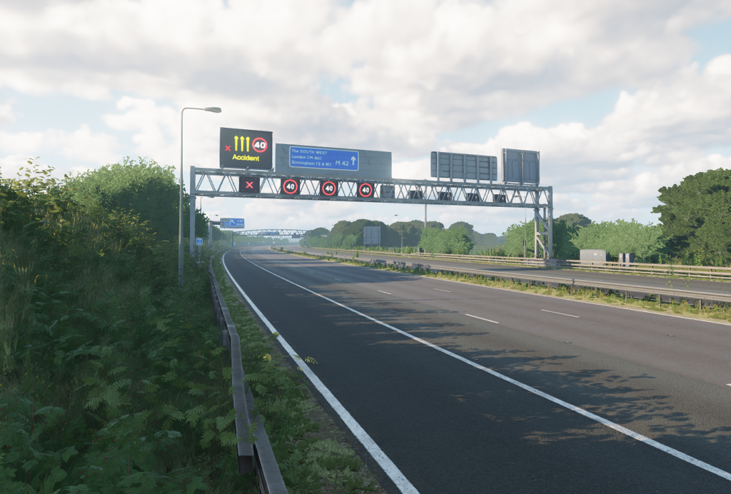
Here’s an image of just one of the many virtual environments we’ve produced for use in simulators:
2. Will your driving simulator terrains work with my simulator? Are they “plug & play”?
We have experience developing driving simulator terrains for a broad variety of simulators and platforms. We understand the needs of your specific platform and design the terrain for that, delivering all required components in appropriate formats.
We deliver driving simulation terrains in standard 3D formats, such as FBX or OSG (.ive), to provide the end user with maximum flexibility.
We deliver driving simulation terrains in games engine formats, for example as Unity or Unreal Engine projects, to import into proprietary or custom simulators, for example those built on Simulink, SVL, CARLA or CarSim.
We also deliver packaged terrain databases in proprietary formats to work with specific driving simulation software, for example:
- AV Simulation SCANeR, to work with the UXD Engine or the legacy OSG Visual system. We can also provide SCANeR .rnd files and rolling road surface models.
- IPG CarMaker, packaged to work with the MovieNX visual system.
- NVIDIA DRIVE Sim.
Alongside the visual 3D environment model we can provide logical maps for driving simulators, for example OpenDRIVE (.xodr) format.
With a visual environment designed specifically for your simulator visual system and an accompanying logical map in a standard format such as OpenDRIVE, all you should need to do is load the files up in your simulator and you’re good to go!
3. Can you scan real-world locations to create geographically accurate environment models?
Yes, we have an in-house photography capability and we have several trusted partners across the UK and Europe that specialise in LiDAR scanning, stereo photography and surveys of roads, railway environments, proving grounds and racing circuits.
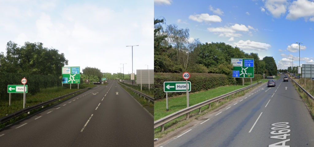
Using scanning technology we are able to replicate real-world environments to a high level of accuracy. Here is a recent example of a route near Coventry in the UK.
4. Do you sell off-the-shelf driving simulators?
We don’t have our own range of “off-the-shelf” simulators, but we will build a custom-designed simulator to your specific requirements and budget. Additionally, we are a UK reseller for AV Simulation who offer a range of off-the-shelf driving simulators.
5. How do your RapidRail tools help de-risk ERTMS rollout?
The rollout of ERTMS across Europe and beyond will reduce travel times, smooth cross-border travel, improve safety and enable more journeys in less time, all on the same track. However, the rollout is a massive and hugely complex undertaking, completely changing the signalling infrastructure and the way trains are driven, and requires careful planning and risk management.
Simulation is an essential tool in the rollout of ERTMS. By planning, trialling, optimising and validating new systems and new processes, issues can be solved early in the project, before the costs to resolve them escalate. Furthermore, stakeholders can understand how new systems will affect them and their teams, can provide essential input early in the process, and can trial or compare options. This enables delivery teams to optimise systems and workflows to ensure human factors are properly considered, processes are safe and activities properly planned.
There are several highly capable engineering simulators that enable the railway and the ERTMS to be accurately simulated and representative scenarios played back. However, to fully benefit from all that this simulation can offer, it is essential to get the “driver-in-the-loop”, participating in trial scenarios and providing insight from their unique perspective. Typically, railway engineering simulators do not include high quality 3D visuals so are unable to provide the all-important view from the driver’s cab. This makes involving drivers in the simulation very difficult.
This is where RapidRail comes in. RapidRail is designed to integrate with railway simulations and provides a high quality real-time visualisation of the view from the train cab, providing the necessary visual cues bringing the driver into the heart of the simulation. RapidRail also provides the ability to quickly reconfigure infrastructure elements, change signage and swap signalling schemes. To complete the package, RapidRail enables users to create new visual models, replicating real routes, quickly and intuitively without the need to involve 3D modelling teams or specialist resources.
6. Can you supply simulation visuals of real-world railway locations?
Yes, whether you are looking for geographically accurate visuals of a 30-mile main-line route to support ERTMS rollout, comparison visuals between current and planned future depot designs or detailed models of a station to get stakeholder feedback and share plans for a new design, we’ve got you covered.
We can scan and survey locations, and we can work from existing track and infrastructure data.
Using the procedural modelling algorithms in our RapidRail tools, we can quickly and efficiently create large stretches of virtual railway. And using industry standard modelling tools, working from CAD or BIM data, scans, plans or measurements and photographs, we can create highly detailed and accurate digital 3D replicas of stations, infrastructure and features along a route.
7. What Railway Simulators does RapidRail work with?
RapidRail has been designed to easily integrate with a broad range of Railway Simulators. Provided your simulator is able to provide basic information such as train positions and signal states we will be able to integrate RapidRail and provide high quality visuals that reflect what is happening in your simulator.
Simulation Data can be shared with RapidRail via a variety of technologies including TCP/IP, DDS/OpenSplice, XML/UDP, though shared memory or a shared database.
8. What do you mean by “Realtime Simulation Visuals”?
Real-time simulation visuals are computer-generated images or graphics that are created in real-time during a simulation. Real-time simulations are designed to model a specific scenario or situation, and they often involve complex systems or interactions that can be difficult to visualise. Real-time simulation visuals are used to help users understand and interpret the data and information generated by the simulation.
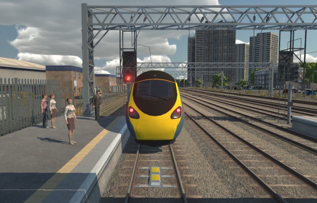
Typically, in the work we do, real-time simulation visuals present a live view of the world as seen from a particular role or player in a simulation, for example the driver of a train.
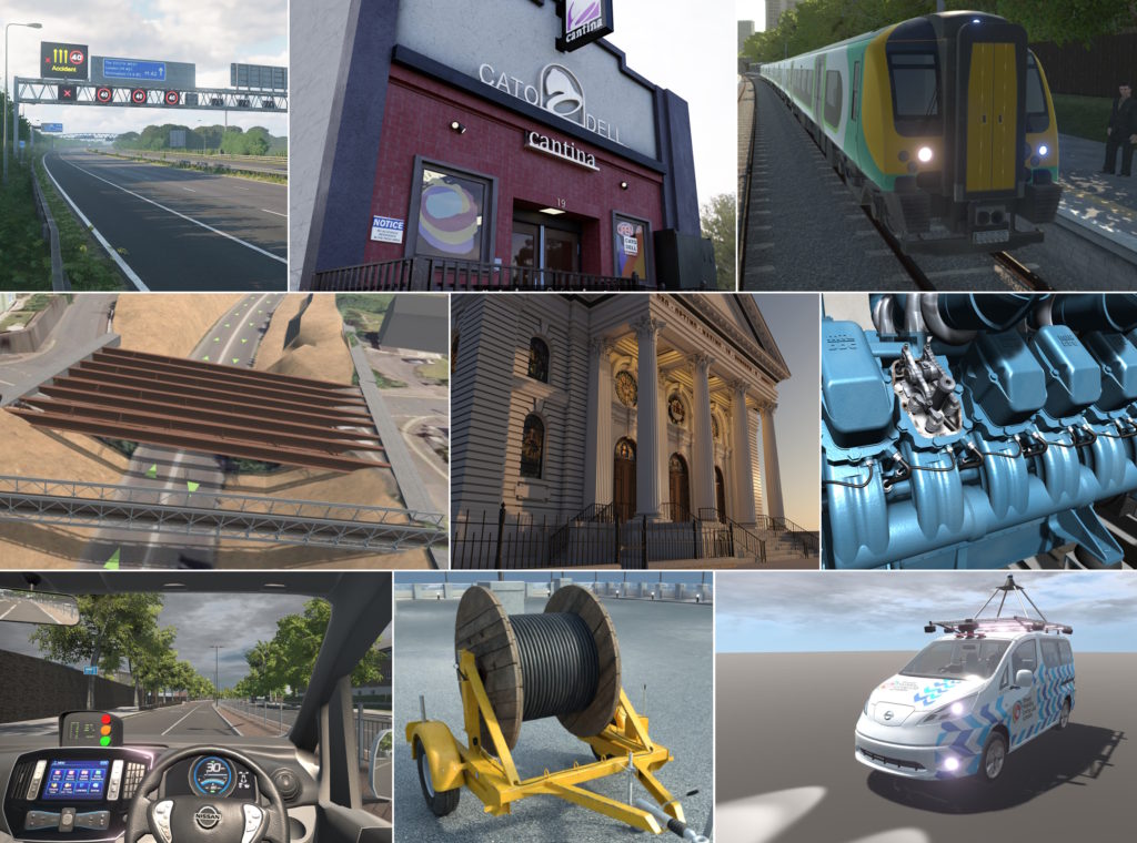
9. What is Virtual 3D Content?
3-dimensional computer-generated graphical representations of anything from an individual vehicle for use in a driving simulator to a large transport network.
We create virtual 3D content for use within the software applications that we develop, such as the VirtuRail project, developed for Transport for London. We develop content that is configured and optimised to be used within real-time simulators and applications that our clients already have, for example for the work that we have been doing for NVIDIA.
The image below shows various examples of the virtual 3D content we have developed…
10. What are Virtual Reality (VR), Augmented Reality (AR), Mixed Reality (MR) and “XR”?
Extended Reality (XR) is a general term that includes Virtual Reality (VR), Augmented Reality (AR) and Mixed Reality (MR). On the whole, XR refers to those interactive 3D technologies that, in some way, alter a user’s experience of reality. Currently, all of them present the user with a ‘filtered’ reality through a computer device. For instance, VR requires the user to wear a Head Mounted Display (HMD), some AR technologies use HMDs, but many AR applications utilise mobile device cameras and screens and MR technologies are similar to this.
Through wearing a Virtual Reality HMD, a user’s reality is replaced with one that is entirely computer generated. The user can be transported into a real-world-based situation or into a completely fictitious reality that they may never otherwise be able to experience. Common with VR systems, are hand-controllers. The user can manipulate these in order to interact with virtual objects within their alternate reality. This provides a rich, sensory experience for the user that is astonishingly immersive.
As its name suggests, Augmented Reality is concerned with adding to a user’s normal reality. Normally through either a HMD or a mobile device screen, the user experiences the world around them but with the inclusion of augmented data. This ‘augmented data’ can range from textual information to overlaid map directions to animated 3D objects, characters and effects.
Mixed Reality can be considered as an extension of AR. In MR, by employing image recognition technologies, the ‘augmented data’ itself has some awareness of the real-world and so can react to real-world objects. For instance, a 3D character could ‘hide’ behind a real-world chair – something that isn’t possible with basic AR since the ‘augmented data’ is presented as an image overlay.
All of these technologies are relatively new innovations. They are gradually establishing themselves and, as truly transformative technologies, are carving a new technology landscape.
11. Can you give me a demonstration of your software?
Yes, we would be delighted to demonstrate our software. We can do this in person if you are fairly local to us, or we can give a demonstration over Teams or Zoom.
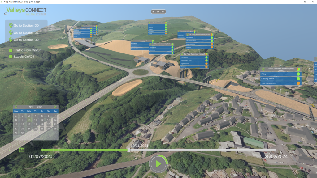
12. What are interactive 4D technologies?
The 3-dimensions of space are familiar to us all, but the fourth dimension referred to here, is the time dimension. If you have a requirement, or if it would be beneficial to have the progression of time simulated within an application, then 4D functionality can be built on top of your interactive 3D solution.
The image below demonstrates where we have done this on a previous project. A 4D timeline was incorporated to enable the client and their stakeholders to see how their infrastructure development project would progress over time, including a calendar, speed and Play/Pause controls.
13. How much does it cost to develop an interactive 3D application and how long does it take?
A popular question and one that is very difficult to answer as price and duration are very dependent on the specific requirements for the solution you are looking for. The beauty of building bespoke applications is that we can tailor them to your budget. Get in touch if you want to understand more about our range of solutions and pricing options.
Whatever your budget, it is our ultimate goal to deliver solutions that solve problems and help you and your organisation to make good decisions at the right time.
14. How much does it cost to develop a new driving simulator environment and how long does it take?
Again, a very popular question and one that is very difficult to answer as price and duration are very dependent on the specific requirements. Typically it takes us between 2 and 6 months to develop a new driving simulator environment. The time and effort required is dependent on a number of factors including:
- The physical size of the route to be modelled,
- The nature of the route, for example urban, rural or off-road,
- The complexity of the route, for example how many complex junctions are included,
- Whether an accurate geospecific model is needed, or whether a geo-typical environment is suitable,
- Whether scanning is needed,
- How far can be seen from the route and the type of terrain, e.g. flat or mountainous,
- How much of the environment can be generic, and scenery objects reused,
- What the target platform is, formats required and performance limitations,
- Whether night-time elements such as illuminated building interiors are needed,
- Number and complexity of interactive elements, for example level crossings or smart motorway dynamic signage,
- Whether roadworks are to be modelled,
Whatever your requirements and budget, in most cases we can design a solution that provides what you need and fits your budget.
15. What is a Train Driver DMI?
The train driver’s DMI (Driver-Machine Interface) is a user interface on board the train that presents important information to the driver, such as the current and the permissible speeds for the train. The DMI is a key component in the new ERTMS/ETCS train control system.
16. What is a typical project size? Is any job too big or too small?
Our projects typically last from a few days to 6-8 months in duration. We are a small business run by enthusiasts and we would never turn down a project for being too small if it is something that appeals to us and that we feel we could do well. Being an SME, there are limits to the size of project we are able to commit to, but this is very rarely an issue. We have worked on some major projects for big name clients (and gone through the supplier approval / onboarding processes that typically go with large organisations) and we have partners we collaborate, with to deliver projects of almost any size. If in any doubt, contact us to discuss your ideas and we’ll go from there.
17. What will be needed from me during the project lifecycle?
Your time is an important and essential asset to us, both before and during a project. Early our engagement, your time will be required to talk with us about your requirements, share information and agree plans for the project. This will shift to time being spent reviewing in-progress deliverables and providing feedback as we provide as we move through the project lifecycle.
Data is also a crucial aspect of any project and the more, good quality data you are able to provide, the better. We will discuss all data requirements with you. For more information on data, please see question 19.
It may also be necessary to have access to subject matter experts, specific locations to gather data, equipment and other things during the course of a project.
We will always be clear in our discussions and proposals regarding what will be needed from our clients for any project. For more information on how we organise our projects, see the “Working with us” section of our website.
18. Can Agility3 solutions integrate with my existing systems?
Of course! We have a great deal of experience designing and developing integrated solutions. Whether your system already exposes API hooks, publishes network data or requires the development of a new external interface, we can help.
We have developed applications that communicate with our clients’ existing software systems through a variety of protocols and data formats. The precise definition of interfaces between software components can be make or break for an integrated software solution. We therefore take especially great care in the design, implementation and testing of our interface definitions.
19. What type of data will be needed for my project?
When we say “data” we’re talking about the technical information necessary to define the behaviour, characteristics and/or content of the required solution. Generally, the better the quality of data that is available for your project, the better the quality of the developed solution and the more cost effective it is. Therefore, the importance of data cannot be understated.
The data needed for your project will depend on your use cases. For example, for a driving simulator environment we typically need LIDAR Scans, elevation models, aerial imagery, photographs, BIM Data and information about the target platform. Of course, we are experienced in sourcing this information ourselves so don’t worry if you don’t have this already.
For a railway environment we typically need geographical data describing the centreline of the tracks, locations of infrastructure equipment and platforms, cab view video, photographs and BIM data if available. We also need information on any simulator interface, in a visualisation application is required.
We will always discuss with you what data will be useful, what can be acquired, and what impact this will have on the project.
20. I’m not able to provide the required data – is that a problem?
Not usually. We are very capable and experienced in sourcing data ourselves or through third parties. However, there may be time and cost overheads associated with acquiring data in this way which would need to be considered.
21. I think my business could benefit from an interactive 3D or 4D application, but I would like to try and test a solution first before fully investing – is that possible?
Yes, certainly! During our early discussions with you we will always present, demonstrate and allow you to try previous solutions we have developed that are relevant to your requirements, to help you understand how a solution developed by Agility3 could benefit your organisation and use case.
If you would like to go one step further, a good approach and one we recommend is to develop a low-cost bespoke “proof-of-concept” solution tailored to your use case. This typically involves building a “cut-down” version of the full solution that you’re interested in for a “cut-down” price in order to showcase some of the main features. The main aim of this is to give you confidence that the solution is right for your organisation, help inform the requirements (it usually sparks new ideas and help gather new requirements from stakeholders which add value to the application), and show you what we’re like to work with before make a larger commitment. If you’re happy, we can then build upon that “proof-of-concept” to reach the full solution. This can be done in one go, or incrementally, adding functionality as and when required or when budgets allow.
22. Can I have an interactive 3D application launched and accessed through the internet?
Yes, you can. There are several options to choose from when it comes to deploying and accessing the solutions that we develop, and we will discuss with you what the best method/s will be.
Launching and accessing your application over the web is absolutely one of the options and is particularly beneficial when your end users are distributed across many different locations.
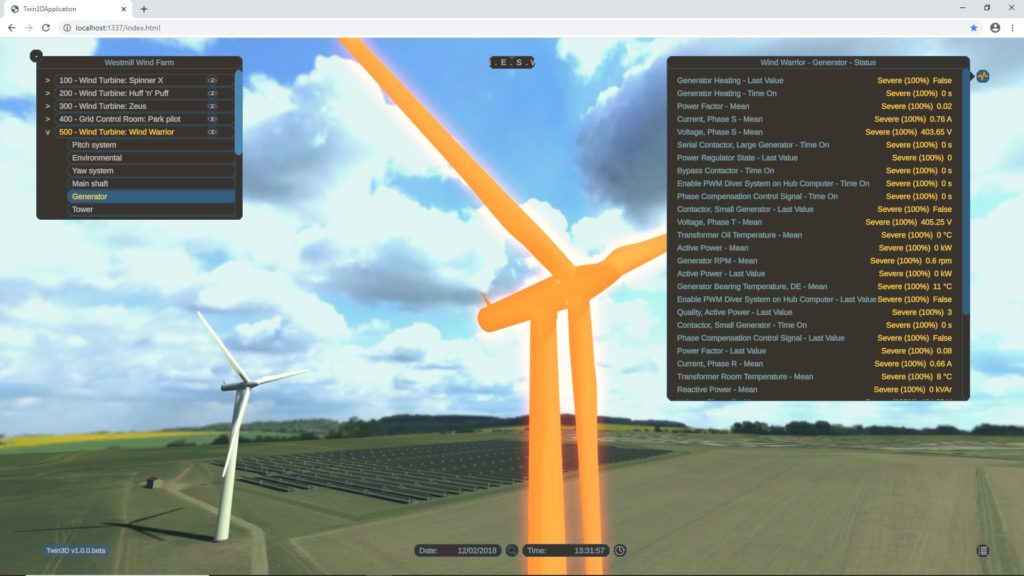
The image below is taken from the “WindTwin” project which is an example of a solution that is deployed through the cloud.
23. Who will own the Intellectual Property of the solution developed for my project?
This is something that, as a company, we are flexible on. We have delivered solutions where all the IP of the solution is owned by the client upon delivery for a fixed price and we have also delivered solutions where the IP is retained by Agility3 and the solution is provided on a licence basis.
We will discuss this and other commercial elements with you to ensure that all parties are happy and in agreement prior to the commencement of the project.
24. Do you provide maintenance and support on the solutions you develop and deliver?
Yes, we can absolutely build maintenance and support packages into our proposals if so desired. We can also offer separate support contracts to help maintain and enhance your solutions into the future.
25. Why should I choose to work with Agility3?
We are a team of friendly experts, passionate about simulation and 3D visuals, who want to help your organisation solve problems, improve efficiency, validate designs and engage stakeholders, through the application of simulation and visualisation.
We offer a wealth of specialist experience in 3D modelling, 3D virtual environment creation, driving simulation, railway simulation, 3D visualisation, interactive training, VR and AR alongside a bucket load of creativity and enthusiasm. We’re used to working with businesses of all sizes and types from small startups creating a Minimum Viable Product through to large multinational corporations and government organisations. We understand your business challenges.
We are independent with a broad understanding of the available technologies and vendors, and so are open to select the best tools for each project. We’re constantly growing our technical ability and looking to push technology boundaries.
We pride ourselves on being an agile, flexible, responsive business that is easy to work with, will deliver on time, will help you manage risks and resources, offer excellent value and will go the “extra mile” when needed.
If you think you have an idea or project in mind that we might be able to help with, do get in touch for a chat, we would love to hear from you.
26. I want to work with you, what should I do next?
Fantastic! We’d love to get in touch with you to discuss your project.
Feel free to give us a call on +44 (0) 1438 488066 or email us on info@agility3.co.uk!
Or if you’d prefer, you can fill in our contact form with a suitable time for us to call you by clicking the button below, we look forward to speaking with you!